Robot Navigation Map: Your Robot Won’t Get Lost
Table of Contents
A robot navigation map is the core foundation for a robot to achieve autonomous navigation, environmental interaction, and task execution, directly impacting the accuracy, efficiency, and reliability of navigation.
Definition of Robot Navigation Map
A robot navigation map is a spatial information representation that a robot relies on for autonomous navigation within an environment. Specifically, it is a mathematical model or data structure formed by processing, fusing, and abstracting sensor data (such as LiDAR, cameras, ultrasonic sensors, etc.) acquired by the robot through perceiving the surrounding environment. It is used to describe environmental structure, obstacle distribution, traversable areas, and spatial relationships.
Types of Robot Navigation Map
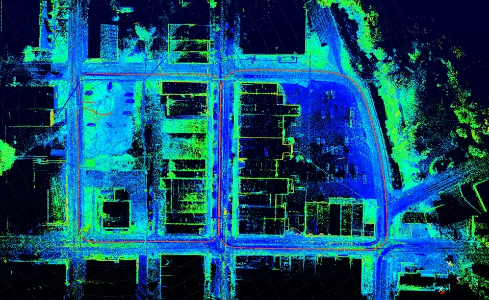
–Metric Map: The metric map is the most classic and widely used map form. It is based on a coordinate system and accurately records geometric information of obstacles and spaces. The metric map answers the question “where are the obstacles.” It is further subdivided into occupancy grid maps, point cloud maps, distance field maps, etc.
–Topological Map: A topological map uses nodes and edges to represent the environment, where nodes indicate important locations (e.g., corners, doorways) and edges represent reachable paths between these locations. Topological maps focus on representing the connectivity of the environment rather than specific geometric details. This map representation is suitable for efficient path planning and navigation in large, complex environments. The topological map answers the question “how to get to the destination.”
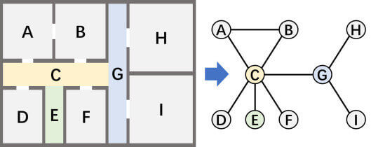
–Semantic Map: A semantic map assigns semantic labels to each spatial element, answering the question “what is here.” Semantic information can include descriptions such as object type, pose, and shape. A region is not only marked as “occupied” but also recognized as a “sofa”; a corridor not only records its geometry but is also labeled as “corridor.”
–High-Definition Map: It integrates metric accuracy, semantic information, and vector representation, making it one of the most complex and information-dense types of robot maps. A High-Definition map is typically composed of a point cloud layer and a vector semantic layer overlaid together.
–Costmap: A costmap is based on the occupancy grid map and introduces an inflation layer around obstacles. This means that grids around obstacles are no longer simply “0 or 1,” but are assigned cost values (typically 0–255) that decrease with distance from the obstacle. A cost value of 0 indicates free passage. The advantage of this design is that the robot itself has size; if path planning only avoids the obstacle’s center point, the robot’s edges might still collide with the obstacle. The inflation zone provides a safety margin.
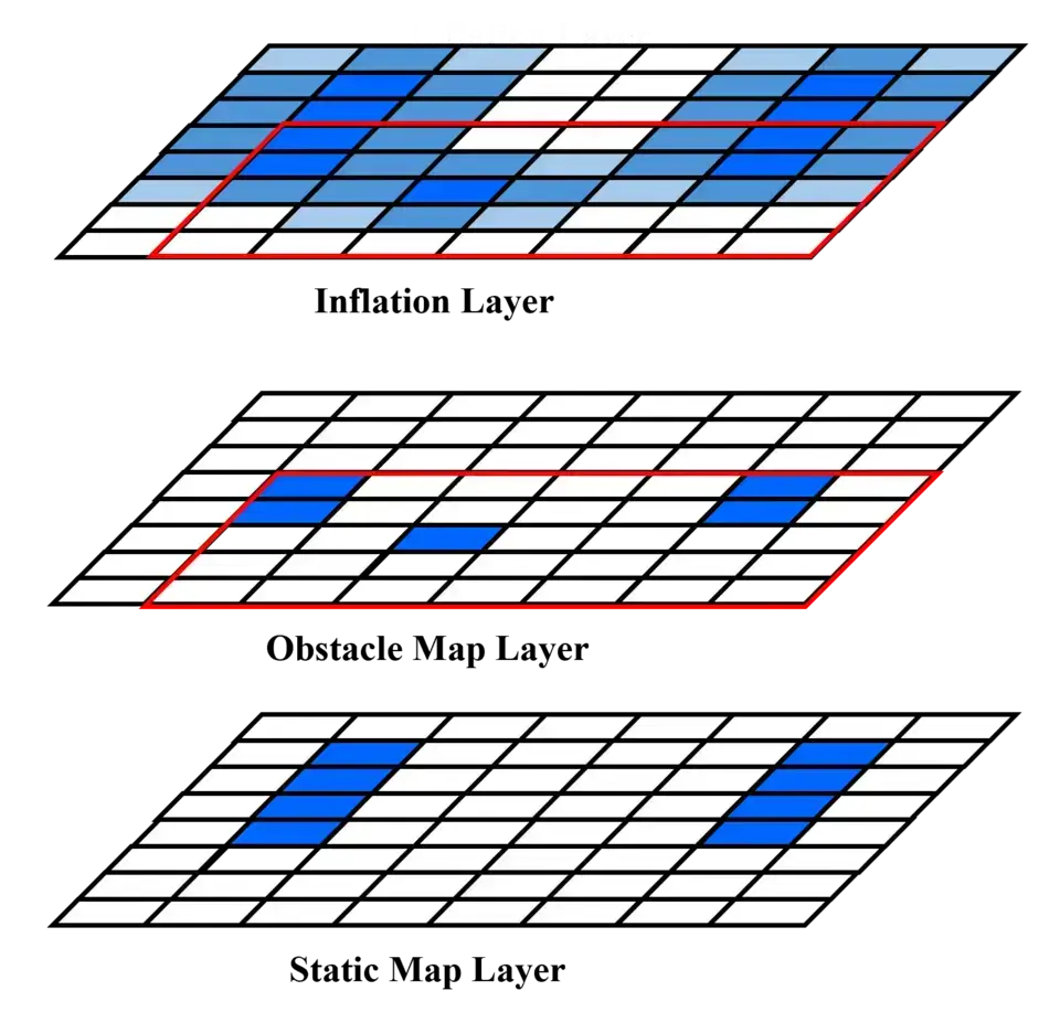
Comprehensive Comparison of Various Map Types:
| Map Type | Dimension | Accuracy | Semantic | Dynamicity | Typical Applications |
| Occupancy Grid Map | 2-dimensional | Medium | None | Updatable | Robot vacuums, indoor navigation |
| Point Cloud Map | 3-dimensional | High | None | Difficult to update | Autonomous driving localization baseline |
| TSDF/ESDF Map | 3-dimensional | High | None | Real-time updatable | Drone navigation, robotic arm planning |
| Topological Map | 2-dimensional / 3-dimensional | Low | Weak | Difficult to update | Large-scale path planning |
| Semantic Map | 2-dimensional / 3-dimensional | Medium–High | Strong | Updatable | Human-robot interaction, service robots |
| Costmap | 2-dimensional | Medium | Weak | Real-time update | Path planning, dynamic obstacle avoidance |
| High-Definition Map | 3-dimensional | Extremely high | Strong | Periodic maintenance | Autonomous driving, ADAS |
Technologies for Building Robot Navigation Maps
Most robot navigation maps are built using SLAM (Simultaneous Localization and Mapping). The core logic of SLAM is to simultaneously perform “localization” and “mapping,” ultimately achieving autonomous navigation. SLAM is a key technology that enables robots to transition from “being controlled” to “acting autonomously,” serving as the “digital navigator” for intelligent devices.
Recommended In-depth Reading from AI Robots Eidos
SLAM (Simultaneous Localization and Mapping) is a core technology that enables robots to achieve autonomous navigation. It not only constructs navigation maps but also provides robots with localization, path planning, and dynamic adaptation capabilities, allowing them to safely and efficiently complete tasks in complex, unknown environments.
If readers want to gain a comprehensive understanding of SLAM technology, please refer to this article on Simultaneous Localization and Mapping.
Process of Building a Robot Navigation Map with SLAM
–Environment Perception:
LiDAR: Emits laser beams and receives reflected signals to generate high-precision 3D environmental point clouds.
Cameras: Recognize features through visual images; low cost but dependent on lighting (e.g., robot vacuums).
Inertial navigation devices: Assist in recording movement speed and angles to avoid short-term positioning errors.
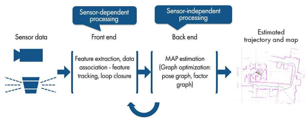
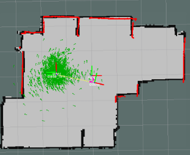
–Localization: The robot uses a prior map (a pre-built and saved occupancy grid map or point cloud map) and matches it with real-time sensor data to estimate its own position in the map. The most classic 2-Dimensional localization algorithm is AMCL (Adaptive Monte Carlo Localization). Its core idea is to use a large number of “particles” to represent possible pose hypotheses of the robot, each particle carrying a pose and a corresponding weight. As the robot moves and acquires new sensor data, the particle weights are continuously updated, converging to the optimal estimate.
–Mapping: In the mapping process, depending on the sensors used, it can be divided into LiDAR-based and camera-based mapping. The former means the robot uses environmental laser point information scanned by the LiDAR to construct a global map through local map registration. The latter means the robot captures visual information of the surrounding environment, extracts feature points, and uses the connections between these feature points to build a complete map of the environment. This process is crucial for the robot’s autonomous navigation.
Updating Robot Navigation Maps
–Real-time Data Fusion and Processing: When the robot acquires new environmental data through sensors, the system first fuses and processes this data in real time. For example, color and texture information from RGB images is combined with distance information from depth images. Algorithms align and fuse the new perceptual data with the existing map data, ensuring the map accurately reflects the current actual environment.
–Updating and Recognizing Object Instances: For newly perceived object instances, the system performs detailed feature extraction and analysis, then compares and matches them with existing object instances in the memory map. If it is a newly appearing object, the system creates a new object instance record and stores its position, pose, appearance features, semantic information, etc., into the memory map. If it is an existing object whose position or pose has changed, the system updates its information in the map based on the new perceptual data.
–Extending and Correcting Map Areas: As the robot’s exploration range expands, it may discover new areas or environmental structures. The system then extends the memory map accordingly. For example, when the robot enters a previously unexplored room, it builds map information of that room based on newly acquired perceptual data, connects and integrates it with the existing map, and extends the overall memory map’s coverage.
Through this update mechanism based on new perceptual information, the robot can maintain accurate environmental awareness in complex and dynamic environments, providing reliable map support for its navigation and task execution, thereby further enhancing the robot’s environmental adaptability and intelligence.
System Optimization of Robot Navigation Maps
In robot mapping, distinguishing between long-term navigation maps and short-term navigation maps, and achieving an effective balance between the two, is key to improving system performance and resource utilization efficiency.
–Long-term Robot Navigation Map: When the robot first explores the environment, the system accurately records and stores key information from the environment through high-precision sensor data acquisition and detailed mapping algorithms. During subsequent operations, the system periodically updates and verifies this long-term memory information to ensure its accuracy and reliability. When a long-term structural change in the environment is detected, the system modifies and updates the information accordingly based on new perceptual data.
–Short-term Robot Navigation Map: The short-term navigation map focuses on recording real-time information during the robot’s current task execution. For example, when the robot performs a task of moving an object, it stores the object’s current location, surrounding temporary obstacles, and task-related path information in short-term memory. This information is continuously updated and adjusted as the task progresses and the environment changes. Once the task is completed, the relevant short-term memory information may be partially or completely cleared to free up storage space.
–Balancing Strategy: The robot adopts a dynamic resource allocation and management strategy. Based on task requirements and environmental changes, the system flexibly adjusts the allocation of storage space between long-term and short-term memory to ensure current task needs are met without excessive resource occupation. For example, when executing a complex long-term task, the system may appropriately increase short-term memory capacity to record more task-specific details. When the robot is in a relatively stable environment without complex tasks, more resources are allocated to optimizing and maintaining long-term memory, improving its accuracy and completeness.
Applications of Robot Navigation Maps
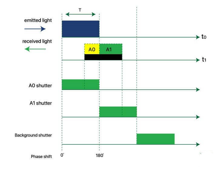
–Robot Vacuums: Modern robot vacuums are commonly equipped with LiDAR or dToF (direct Time-of-Flight) sensors. They use laser SLAM technology to build 2D occupancy grid maps of home environments in real time. After startup, the LiDAR rotates and scans, using cartographer or similar algorithms to build a real-time floor plan (occupancy grid map). Once the map is built, the robot displays the home floor plan to the user via an app, allowing the user to manually delineate cleaning areas and set virtual no-go zones.
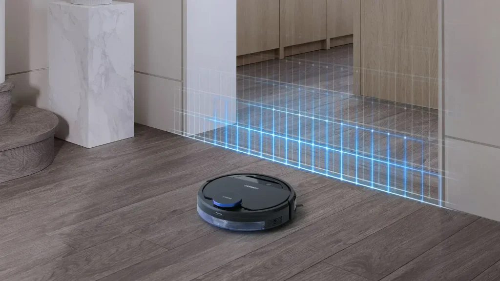
During cleaning tasks, the robot localizes in real time using AMCL, cartographer, or similar algorithms, and uses coverage path planning to systematically clean each area. After each cleaning session, the map records the cleaning status of each area, supporting resumption of cleaning from where it left off.
–Inspection Robots: In scenarios such as substations and power transmission lines, inspection robots build 3D point cloud maps or TSDF/ESDF maps to detect equipment faults, abnormal heating, etc., plan inspection paths, and avoid obstacles. Inspection robots can also use semantic maps to identify equipment, pipes, valves, etc., enabling autonomous inspection, recording equipment status, and timely detection of safety hazards.
–Warehouse Robots: In warehouse scenarios, AMR (Autonomous Mobile Robot) navigation faces challenges such as human-robot coexistence, high-density shelving, and frequent task switching. A hybrid map architecture is typically adopted. This hybrid architecture enables warehouse AMRs to achieve efficient fleet management, real-time obstacle avoidance, and flexible slot management.
Future Directions of Robot Navigation Maps
–Neural Implicit Representation: Traditional maps store information using explicit geometric structures (grids, point clouds, polygons). NeRF (Neural Radiance Field) and 3D Gaussian Splatting represent a completely new map representation paradigm: encoding the environment implicitly into the weights of a neural network, capable of generating highly realistic environment rendering views with very low storage cost. This map representation shows great potential in visual localization, scene understanding, and robot manipulation.
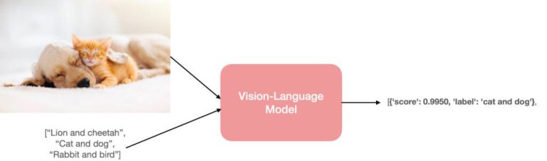
–Fusion of Large Language Models and Semantic Maps: As large language models (LLMs) penetrate the field of embodied AI, robot navigation is moving toward open-vocabulary semantic understanding. Traditional semantic maps can only recognize predefined categories from training sets (e.g., “chair,” “table”). In contrast, new-generation semantic maps based on LLMs and vision-language models like CLIP enable robots to understand more natural commands, such as “put that red cup on the table closest to the window.”
–Continual Learning and Map Self-updating: Real-world environments are dynamic—furniture moves, buildings are renovated, roads are closed. Continual learning mechanisms allow robots to continuously incorporate new environmental changes into the map without forgetting previously acquired knowledge. This is an important capability for long-term deployment of industrial-grade robots.
–Multi-robot Collaborative Mapping: The mapping efficiency of a single robot is limited. Multi-robot SLAM allows a team of robots to collaboratively explore the environment, share local maps, and ultimately merge them into a global map, significantly reducing mapping time for large-scale scenarios such as factories and warehouses.
Insight from AI Robots Eidos about Robot Navigation Maps
—The traditional view holds that navigation maps are a “coordinate reference book” for robots, while future robot navigation maps will evolve into “situational cognitive engines.” With the help of neural implicit representation (such as NeRF), maps will no longer store fixed geometric coordinates, but instead compress the entire environment into the weights of a neural network. This means that robots will not only be able to “query” where obstacles are, but also “understand” implicit attributes such as light, material, and dynamic changes—transforming maps from static data into inferable environmental knowledge models.
—Robot navigation maps themselves will not store all semantic labels but will instead store a “queryable continuous semantic field.” When the robot is in operation, a large language model (LLM) will dynamically parse natural language instructions and query feature embeddings in real-time from the map, enabling target search and avoidance under an open vocabulary—essentially upgrading navigation from “goal point planning” to “intention-driven exploration.”
—In collaborative mapping with multiple robots, due to differences in sensor viewpoints, different robots may produce estimates of the same obstacle or passage width with varying levels of confidence. Future maps will support vote-based updates—where robots exchange not only map data but also uncertainty distributions and observation viewpoints, and the system will automatically identify and resolve semantic conflicts. This will significantly enhance the robustness of mapping in large-scale dynamic environments.
Image Credits: Robotnik & Researchgate & Sciencedirect & Wikipedia & Mathworks & Ecovacs