
Table of Contents
Loop closure detection is a core technology in SLAM (Simultaneous Localization and Mapping) and mobile robot localization and navigation. By identifying whether a device has returned to a previously visited location, it eliminates accumulated errors and optimizes global map consistency. In simple terms, it recognizes repetitive features in scenes to correct accumulated drift.
What Is Loop Closure Detection?
During the SLAM process, a robot continuously estimates its motion trajectory and builds an environmental map using sensors such as odometry, IMU, LiDAR, and cameras. However, these estimates accumulate drift errors over time—primarily cumulative deviations in position and attitude.
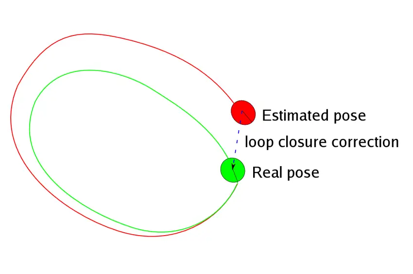
When the robot returns to a previously visited place (i.e., forms a “loop”), the system matches current sensor observations (images, point clouds, laser scans, etc.) against historical observations to determine the similarity between the current position and a past position. If it detects the same location, a loop closure constraint is established, indicating that the current frame and the historical frame correspond to the same physical location.
The Loop Closure Detection Pipeline
–Judging whether the current scene has been visited before: Use methods such as bag-of-words models, point cloud registration, or feature matching to compare against historical keyframes and identify candidate loop closure frames.
–Loop constraint computation: Calculate the relative pose transformation between the current frame and the matched historical frame, establishing a pose constraint edge.
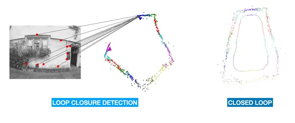
–Loop optimization (backend graph optimization): Incorporate both consecutive odometry constraints and loop closure constraints into a pose graph/graph optimization framework (e.g., g2o, Ceres, GTSAM). This globally adjusts all historical poses, eliminating accumulated drift, straightening the trajectory, and correcting the map.
Recommended In-depth Reading from AI Robots Eidos
The SLAM (Simultaneous Localization and Mapping) system estimates the trajectory through “front-end (visual odometry) recursion,” which inevitably introduces cumulative errors. Loop closure detection is precisely the core error-correction mechanism in SLAM systems, designed to “correct cumulative errors and ensure global consistency.” Understanding the error accumulation mechanism and system architecture of SLAM is the logical starting point for comprehending “why loop closure detection matters.”
Interested readers can refer to this detailed article on Simultaneous Localization and Mapping.
Implementation Approaches of Loop Closure Detection in SLAM
The implementation approaches of loop closure detection differ between LiDAR SLAM and visual SLAM.
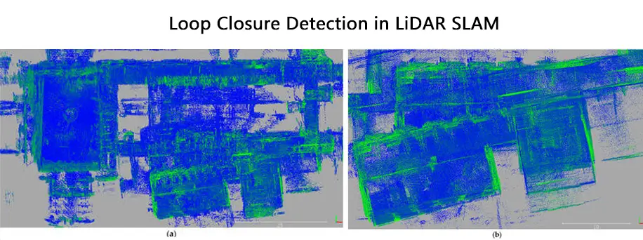
–In LiDAR SLAM: Loop closure detection primarily relies on the geometric features of point cloud data for matching. Common approaches include:
Point cloud registration via ICP (Iterative Closest Point) or NDT (Normal Distributions Transform)
Extracting global feature descriptors from point clouds (e.g., Scan Context) and computing similarity scores to identify loop closures
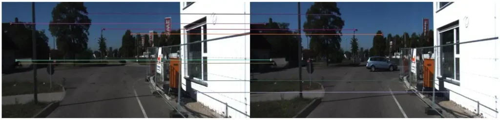
–In Visual SLAM: Loop closure detection primarily relies on visual features from image data for matching. Common approaches include:
Vectorizing image features (e.g., ORB, SIFT) using the Bag-of-Words model to compute image similarity
Leveraging deep learning to extract high-level image features for matching
Common Loop Closure Detection Algorithms
Principle Level
| Algorithm Category | Principle | Characteristics |
| Bag-of-Words Model | Cluster features into visual words; TF-IDF weighted similarity | Relies on hand-crafted features; inverted index for fast retrieval |
| Probabilistic Improved Model | Bayesian filtering for dynamically updating probability distributions | Incorporates odometry and scene dynamics |
| Deep Learning Model | CNNs/autoencoders extract high-level features; approximate nearest neighbor search accelerates matching | End-to-end feature learning; multi-scale fusion |
| Global LiDAR Feature | Geometric features (curvature, centroid, etc.) construct invariant descriptors | Relies on point cloud structure; fast registration optimization |
| Wireless Signal Assistance | Wireless signals filter candidate frames to reduce search space | Multi-sensor fusion; applicable in NLoS (Non-Line-of-Sight) scenarios |
| 3-Dimensional Semantic Co-view Graph | Joint matching using semantic labels + geometric information | Multi-modal fusion; enhanced with high-level semantics |
Instance Level
| Name | Category | Summary |
| Bag-of-Words Model | Descriptor-based Method | Classic approach, but tailored for cameras |
| M2DP | Descriptor-based Method | Computes global descriptors, but takes too much time to process a single point cloud frame |
| Scan Context | Descriptor-based Method | A relatively outstanding loop closure detection method, easy to apply to various LiDAR SLAM systems, but suffers from too many false positives (false loop closures) |
| Scan Context++ | Descriptor-based Method | Improved version of Scan Context, but the paper proposes two variants |
| LiDAR Iris | Descriptor-based Method | Similar in structure to Scan Context, but the time required for descriptor search and matching is too long |
| Intensity Scan Context | Descriptor-based Method | Scan Context that utilizes intensity information, but the source code cannot be successfully executed |
| Imaging LiDAR | Descriptor-based Method | Combines the advantages of LiDAR and camera-based loop closure detection; good robustness, but requires a LiDAR with uniformly distributed beam spacing |
| OverlapNet | Deep Learning-based Method | Good robustness and strong generalization ability, but the input data preprocessing steps are cumbersome and not suitable for deployment |
| OverlapTransformer | Deep Learning-based Method | Improved version of OverlapNet; requires only depth information, fast processing speed, and easy to deploy |
| LCDNet | Deep Learning-based Method | A model that organically combines point cloud registration and loop closure detection |
The Significance of Loop Closure Detection
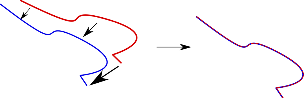
–Correcting accumulated error: During the operation of a SLAM system, sensor noise and environmental interference inevitably lead to accumulated drift. Over extended runtimes, estimated trajectories and maps can deviate significantly from the ground truth. By recognizing that the current scene corresponds to a location recorded in a keyframe from long ago, loop closure provides a powerful global constraint. Although drift has accumulated over time, there exists a specific relative transformation between these two poses. Incorporating this loop constraint into the backend optimization graph enables the optimizer to leverage this global information to correct the entire historical trajectory and map, substantially reducing accumulated error.
–Relocalization: If a SLAM system loses track of its current position due to factors such as rapid motion, occlusion, or drastic illumination changes, the loop closure mechanism can recognize that the currently observed scene resembles a region in the historical map. It can then use this information to re-estimate its pose and achieve relocalization.
–Enabling multi-robot collaborative SLAM:
Centralized architecture: A central server (or master robot) aggregates local maps (submaps) or keyframe data from individual robots. The server handles global loop closure detection, map fusion, and global optimization, then broadcasts the optimized global map back to each robot (e.g., Maplab 2.0, CoxGraph systems).
Distributed architecture: Each robot operates independently, using limited communication (e.g., exchanging only global descriptors) for local loop closure detection. Local data is exchanged only after a loop closure is confirmed, reducing communication bandwidth (e.g., Door-SLAM systems).
Applications of Loop Closure Detection
–Agriculture: Loop closure optimization improves operational path planning and environmental mapping, ensuring efficiency and resource utilization in precision agriculture. For example, when agricultural robots spray pesticides and fertilizers in orchards or perform inspection and maintenance, loop closure identifies and corrects path errors, preventing redundant operations and missed areas, ensuring uniform treatment, and enhancing the precision and efficiency of agricultural tasks.
–Transportation: In complex road sections where active signals like GPS are unavailable (e.g., urban tunnels), loop closure via vision or LiDAR enables high-precision automatic vehicle localization, solving autonomous navigation challenges in unknown segments. In the growing field of autonomous driving, loop closure feeds constraints back to the SLAM backend for pose graph optimization, eliminating accumulated localization drift, constructing globally consistent maps, and supporting path planning.
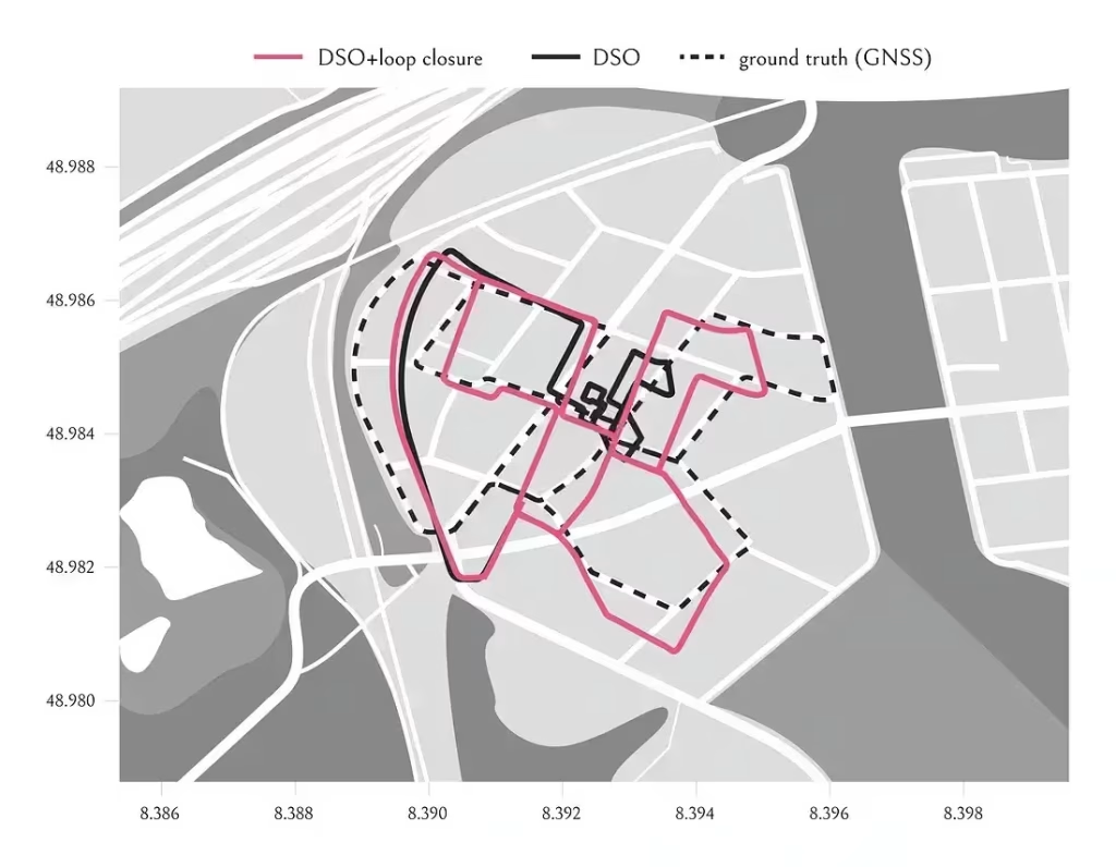
–Wide-area surveying and mapping: Loop closure corrects accumulated drift to ensure centimeter-level accuracy in wide-area mapping. Such mapping often requires multiple passes or sectional surveying, leading to data discrepancies across different time periods and sensors, creating map stitching problems. Loop closure identifies the same location across different times and viewing angles (e.g., via local feature descriptors), enabling map stitching from different devices and perspectives.
Challenges in Loop Closure Detection
–Similarity judgment: How do we determine whether a currently observed scene is “the same as” or “very similar to” a historical scene? This is essentially a problem of Place Recognition or Image Retrieval. An ideal judgment method should possess:
Viewpoint invariance: Recognition even from different viewing angles.
Illumination invariance: Recognition under varying lighting conditions.
Scale invariance: Recognition despite differences in object size due to distance.
Efficiency: Similarity computation and retrieval must be fast enough to compare the current frame against a large number of historical keyframes.
High recall: Identifying as many true loop closures as possible.
–Computational load: As the robot continues to move, the system generates an increasing number of keyframes. Theoretically, each new frame must be compared against all historical frames in the database. Even when eliminating distant frames using spatial constraints, the candidate set grows linearly over time, potentially overwhelming the CPU.
Future Directions in Loop Closure Detection
–Deep learning-based loop closure detection: Advances in object detection driven by deep learning have enhanced mobile robots’ adaptability to dynamic scenes. Unlike traditional methods that separate region proposal and feature extraction, modern object recognition algorithms integrate these components within a deep learning framework to improve both efficiency and accuracy.
–Semantic segmentation-based loop closure detection: Current research incorporates semantic information into SLAM to meet the demands of complex scenarios. Most approaches use extracted semantic information to summarize local features and compare them against global graphs. Semantic SLAM is still in its early stages but holds great promise. The combination of semantic segmentation with deep learning has significantly advanced the field. Key challenges include how to formulate error functions and how to incorporate deep learning-based detection and segmentation results as observations into the SLAM optimization framework.
–Backend optimization integrated with loop closure: The ultimate goal of loop closure detection is to improve backend optimization. Parameters should be tuned in conjunction with the backend optimization algorithm. Identifying more correct loops enhances overall system optimization. Conversely, incorrect loops may cause the optimizer to converge to suboptimal solutions, leading to system failure. Traditional performance metrics focus primarily on precision (accuracy). In some newer backend optimization approaches, the goal is to maintain high precision while maximizing recall, thereby reducing the impact of false loops during optimization. This helps SLAM system designers develop better backends, improving map construction and facilitating the development of more robust SLAM systems.
Insight from AI Robots Eidos about Loop Closure Detection
In the future, the core of loop closure detection will shift from “geometric consistency” to “semantic consistency.” This means that robots will no longer merely “see” a collection of pixels or point clouds, but instead “understand” the objects within a scene (such as a specific tree, a door, or a road sign). When semantic information becomes the primary anchor for loop closure detection, even under drastic changes in lighting or viewpoint, the robot will still be able to complete the loop by recognizing “what objects are in this scene,” thereby achieving human-like scene memory and recognition.
Currently, loop closure detection and backend optimization are often loosely coupled — the loop is first detected and then handed over to the optimizer. A future trend is to design loop closure detection as an end-to-end differentiable module that is directly embedded into the graph optimization framework. In this way, the “similarity score” of loop closure detection can be backpropagated and participate in the joint optimization of the pose graph, rather than simply providing a binary “yes/no” decision. Detection and optimization will become an organic whole: the system will not only use loop closures to correct poses, but also leverage the optimized poses to guide more accurate loop matching.
Current loop closure detection is a passive behavior — the robot goes wherever it goes and only triggers a loop when it happens to revisit a previously mapped area. The future direction is to endow robots with active loop closure planning capabilities. When exploring unknown environments, the system can evaluate the current cumulative drift risk in real time and actively plan a “loop closure path” — that is, to deliberately return to a previously mapped area to form a loop and “calibrate” its localization. This is a new paradigm that integrates mapping, planning, and loop closure detection into a closed loop, especially suitable for scenarios such as underground mines and deep-space exploration where GPS is unavailable and extremely high precision is required.
Image Credits: Thinkautonomous & Researchgate & Mdpi & Frontiersin & Pave-robotics & Medium